

Sea-level rise is often cited as the main cause of rising groundwater that inundates low-lying coastal communities. However, in the port city of Gwadar on Pakistan’s Makran coast, the causes are more complex and interconnected. Rising groundwater in Gwadar results from both climate change and human activities.
Sea-level rise pushes saltwater upward, and years of over-pumping draw seawater into aquifers—underground layers of water-bearing sediment.
With 80% of the city lacking a sewer system, wastewater seeps into shallow aquifers, directly raising groundwater. Land-use changes, such as encroachment and reclamation (the conversion of sea to land), disrupt natural drainage, preventing runoff from reaching the sea and instead increasing water retention. These combined changes reduce the land’s ability to absorb rainwater, leading to frequent flooding, ecological disruption, and threats to city foundations.
Around the world, coastal aquifers are feeling the pressure of rising seas. Driven by climate change, denser seawater creeps inland beneath lighter freshwater, increasing pressure underground and pushing water levels higher. In low-lying Gwadar City, this link is direct: its shallow, unconfined aquifer connects straight to the Arabian Sea. When heavy rain or high tides saturate the aquifer, the water table can climb above the ground surface, unleashing groundwater inundation in the city’s lowest neighbourhoods flooding that comes not from the sea’s edge, but from beneath residents’ feet.
Over the past three to four years, Gwadar City’s coastal community has experienced intermittent groundwater inundation, even in the absence of rainfall.
Previously, according to Qadir, a resident of Port City, flooding only occurred during the rainy season and would recede within a week. However, after the heavy rainfall of 2024, he notes that the flooding has become more frequent and severe, making many areas uninhabitable.
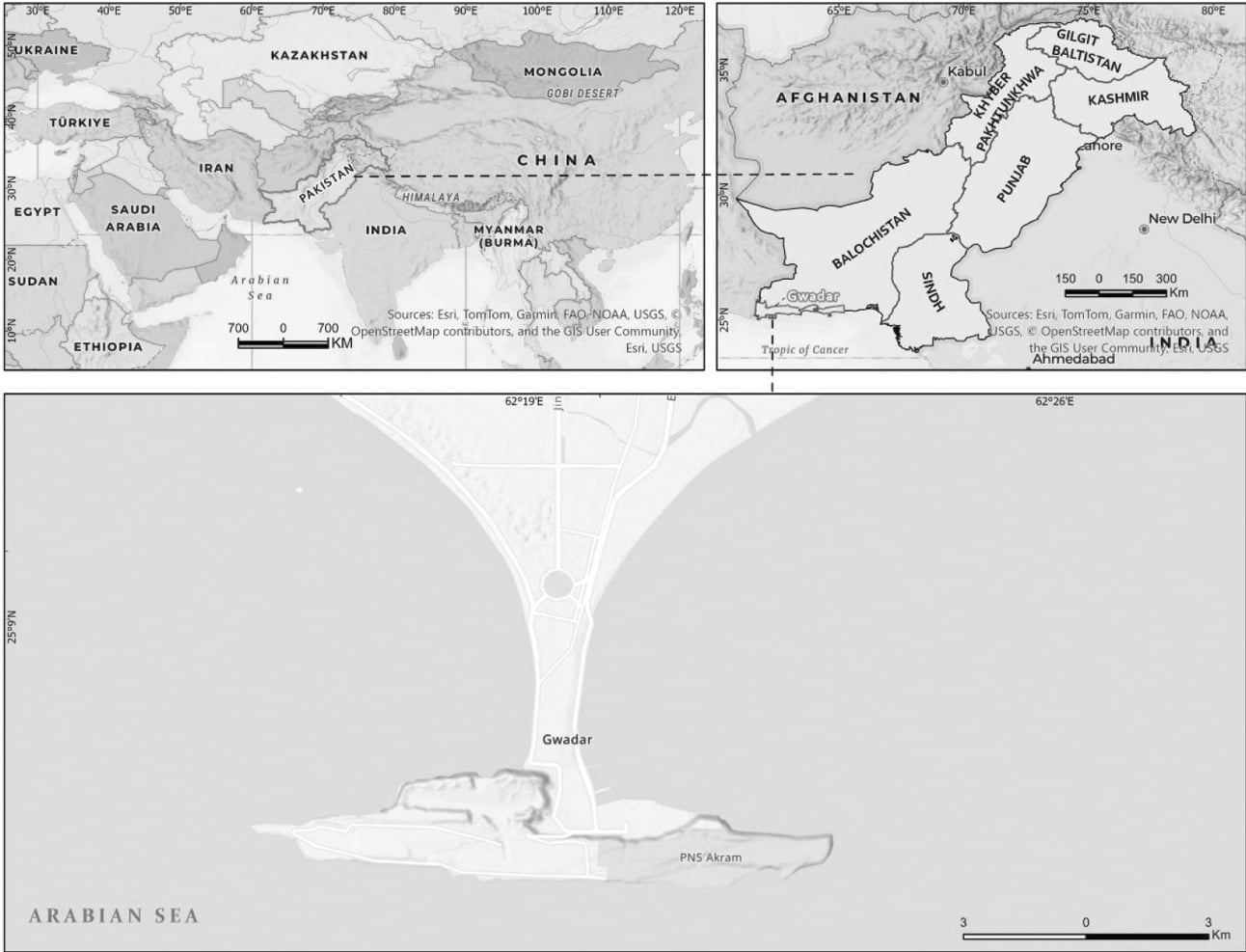
Gwadar City comprises 42 wards and supports a vibrant community of approximately 150,000 residents. Guarded by the shimmering Arabian Sea on three sides, the city unfolds across a low-lying coastal expanse of about ~ 20km². Nearly all of this terrain, about 90–95%, is less than 10 meters above sea level, forming an expansive low-elevation coastal zone (LECZ).
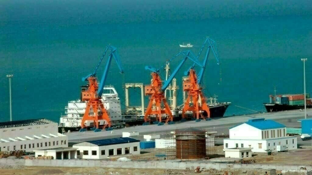
Situated near the Strait of Hormuz, a major global oil shipping lane — Gwadar City is rapidly becoming a commercial center. The completed Gwadar-Kashgar Highway, a segment of the Pakistan-China Economic Corridor, directly connects the port to China and Central Asia. Positioned as a critical entry point to the Arabian Sea, Gwadar serves as a vital link between the Silk Road Economic Belt and the 21st Century Maritime Silk Road. Its location and infrastructure enable the port city to spur economic revival for both the province and the nation.
Today, ocean and sea coasts are home to 2.4 billion people—approximately 40% of the world’s population. In fact, approximately 11% (around 896 million) of the global population resides in areas that are less than 10 meters above mean sea level (MSL).
Moreover, coastal regions host 75% of the largest metropolitan areas. Looking ahead, the population in low-elevation coastal zones—defined as areas within 10 meters above sea level—is projected to reach 1.4 billion by 2060. These low-lying coastal areas have undergone rapid industrialization, urbanization, and the development of critical infrastructure, leading to significant socioeconomic activities.
Addressing this growing risk requires immediate attention and coordinated action from policymakers, urban planners, and communities to ensure the resilience and safety of vulnerable populations. The situation in Gwadar exemplifies these challenges, as a lack of public awareness, adequate planning, and coordination starkly highlights the risks facing coastal communities.
The City sits on a sandy isthmus stretching 12km north to south, narrowing to under 1km at its slimmest and widening to 6.5km at its broadest. This unique geography brings vulnerabilities. Natural dunes create uneven land heights, causing localized elevation changes from +21m (Latitude 25.180376, Longitude 62.330108) to -7m (Latitude 25.163119, Longitude 62.327155) above mean sea level.
As a result, surface and subsurface water flows are distorted. Some depressions are vulnerable to sea level rise even near higher ground. This dual elevation profile increases the risk of waterlogging, saltwater intrusion, and sea level driven groundwater induced inundation.
Khudabux Hashim, a 76-year-old retired teacher, recalls playing as a boy on the city’s sand dunes, never imagining that fresh water would one day lie just beneath them.
Based on infrastructure, Gwadar city can be divided into an old city and a new one. Most markets, schools, public offices, hospitals, and seaports are in the old city. While the old city area is relatively highly populated and unplanned, with more aging infrastructure, its counterpart, the new city, differs significantly in these aspects.
According to the Köppen climate classification scheme (BWh), Gwadar City has an arid desert climate characterized by hot, dry conditions, long, hot summers, and short, mild winters. On average, the city receives less than 100 millimeters (4 inches) of precipitation annually. However, in 2024, it experienced an unusual occurrence when it received over 180 mm of rain in just two days in February.
Coastal storms caused by the Phet cyclone in 2010 and the Gonu cyclone in 2009 flooded both bays, seriously damaging buildings and roads. In response, city planners considered how rising sea levels might cause more flooding on land, potentially affecting homes and properties along both shores in the near future. So, local authorities built seawalls on both coastlines.
The adaptation method focuses exclusively on overland flooding. These seawalls are designed to prevent the impact of higher sea levels. However, the project did not consider that underground water could also rise.
The seawall blocks the sea but not groundwater, which can move easily through the loose sand. The seawall in the western bay altered the natural land slope from “land to sea to sea to land,” causing water to pool on the surface and leading to groundwater flooding in nearby neighbourhoods, such as Bakshi and TCC Colony. These changes have caused residents to worry about potential damage to their properties and possible long-term environmental harm to the area.
(To be continued)
Copyright Business Recorder, 2025


Comments
Comments are closed for this article.